


Orbit PanoViewer app for iPhone and iPad
Developer: Orbit GeoSpatial Technologies
First release : 22 May 2010
App size: 4.99 Mb
The Orbit GT PanoViewer App for iPhone/iPad grants access to panoramic or 360 degree images provided by a dedicated server or party and provides overlay of LiDAR point clouds collected by any Mobile Mapping system.
NEW IN VERSION 10.5.2
- Support for iOS 9
- Some minor bug fixes
Orbit GT PanoViewer 11.1 supports the following mobile mapping content services :
1. Connect to an instance of the Orbit Mobile Mapping Publisher.
- You will require to enter server location, login and password.
- You need to request this from your content provider.
2. Connect to an earthmine Cloud online service
- You will require to enter your login keys
- You will need to get your login keys from earthmine at [email protected]
3. Connect to Cyclomedia Atlas online service.
- You will require to enter unlock code, login and password.
- You can request an unlock code from http://www.orbitgis.com/store/product/orbit-ios-panoviewer (free). Register or Login to the site to get a free unlock key.
- You need to use your Cyclomedia User Account or request a login an password from Cyclomedia at [email protected]
For your convenience, a set of demo projects is available from our Orbit Mobile Mapping Publisher servers.
Key Features :
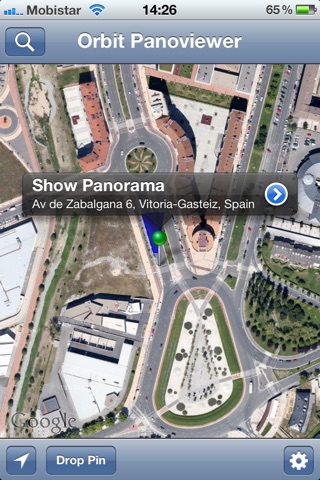
* Find pano by map
* Find pano by address
* Show my position
* Drop pin to select pano
* Move pin to select pano
* Automatic calculation of address (nearest address to pano recording position)
* View pano in portrait and lanscape mode
* Fluent and intuitive scroll, pan, tilt, zoom
* Split-screen combining Map and Pano (only iPad in portrait mode).
* Field of View display on Map
* choose basemap as streetmap, sattelite or hybrid
* Easily move to other pano nearby
Only for Orbit Publisher connections :
* List and free access of Demo Projects
* show Photo Recording exact positions on map (when zoomed in)
* show Photo Recording coverage on map
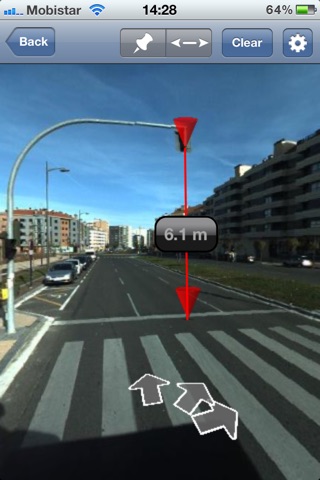
* show LiDAR Point Cloud as overlay on panorama (colored according to distance from viewing location)
* allow choice of Projects within publication.
For Orbit Publisher and earthmine server connections :
* Measure a Position
* Specify units to display co-ordinate
* Measure a Distance
* Specify units to display distance
Note : Measurement is only available for Publications that include a point cloud. Measurement is not possible for Publications with imagery only or for Cyclomedia Atlas.
PREVIOUSLY NEW IN VERSION 10.5.1
- Support for iOS 8
- Some minor bug fixes
PREVIOUSLY NEW IN VERSION 10.5
- Support for iOS 7
- Support for LiDAR Point Cloud overlay on panoramas
- Support for Photo Recording Locations on the map (zoom in !)
- Maximum compatibility with Orbit Publisher 10.5
PREVIOUSLY NEW IN VERSION 10.4
- added support for the earthmine Cloud services
- added support for street, sattelite and hybrid basemaps
- improved presentation of point measurement display
- added support for Lat/Log or WGS84 representation of co-oordinate
- improved support for metric/imperial representation of a measured distance or height
- improved configuration of Mobile Mapping hosting services access
- added quick list of publications available from a server
- a range of minor bug fixes and usability issues
COMPATIBILITY
This App requires an iPhone/IPod Touch or iPad versions from 3G up, or iPad to run, with at least iOS 6 installed. Supports Retina Display.
COPYRIGHT
Orbit GT NV, Belgium 2015
http://www.orbitgt.com/content/mm-ios-panoviewer
DISCLAIMER
Orbit GeoSpatial Technologies is not responsible for the use or misuse of this app or the content enabled by this app. Only the providers have responsibility of the content they provide. Users have to realize that content might contain content with restricted right-to-use. Use at own risk and responsibility.
For full disclaimer, please consult www.orbitgis.com.